Exploring fish habitat use to explain differential commercial and sport catch
Overview
Fish populations in freshwater lakes and coastal environments are facing rapidly deteriorating oxythermal habitat conditions from the interaction of climate change and watershed land use. When these populations serve as the basis for fisheries, the uncertainty in how habitat-use changes with the degradation of the environment leads to uncertainty for both the fisheries and the management of those fisheries. This project focuses on understanding the drivers of and patterns in shifts in fish habitat-use in response to hypoxic conditions (“dead zones”) and the consequences for the fisheries. Specifically, we will study how hypoxia affects yellow perch distribution in the central basin of Lake Erie and how this is reflected in the commercial and recreational fisheries.
The goal of this project is to understand shifts in the spatial and temporal distribution of adult yellow perch in response to changes in environmental conditions and how these shifts help explain recent mismatches between commercial and sport fishery catches.
Objectives
- Estimate habitat quality in terms of growth potential as a means of determining the effects of changing environmental conditions on yellow perch behavior and distributions in the central basin of Lake Erie
- Test whether yellow perch distributions correlate with predicted growth-habitat quality
- Compare model predictions of growth-habitat quality, field abundance patterns, and patterns in catch and effort by commercial and sport fisheries to understand the source of discrepancies in the fisheries
Hypoxia is a stressor for many fish species, eliciting physiological responses and altering the behavior of individuals. Although direct mortality of fish can occur as a result of hypoxia exposure, sublethal effects are more common but poorly understood. Sublethal effects of hypoxia exposure include reduced feeding, growth, and reproductive potential as well as behavioral avoidance of hypoxic areas. In fact, many fishes shift their spatial distribution in response to hypoxia. Some species are known to aggregate at the edge of hypoxic zones and undergo foraging forays into hypoxic areas to feed on the benthos.
In Lake Erie, the southernmost and most productive of the Laurentian Great Lakes, thermally induced stratification and increased nutrient inputs have led to increases in the magnitude, frequency, and spatial extent of hypoxic events, which alter habitat quality and impact ecosystem dynamics. Hypoxia is most pronounced in the hypolimnion of the central basin, the largest of the three basins of Lake Erie, during the late summer and early fall and is known to affect the spatial distribution of yellow perch (Perca flavescens), which supports the largest commercial fishery and second largest recreational fishery in the lake. Changes in the spatial distribution of yellow perch may affect catch rates in these fisheries.
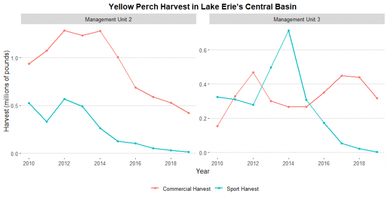
Previous research, and management groups such as the Great Lakes Fishery Commission Lake Erie Yellow Perch Task Group, have used a combination of fishery-independent surveys (trawl and gill net), commercial harvest, and recreational angler catch rates to effectively assess species in the Great Lakes. In recent years, however, the agreement between these indicators of yellow perch abundance in the central basin of Lake Erie has decreased (YPTG 2019). Specifically, in the western half of the central basin (Management Unit [MU] 2), both commercial and recreational harvest have been declining, with recreational harvest decline beginning after 2012 and commercial harvest decline beginning two years later. In the eastern half of the central basin (MU3), recreational harvest has been declining since 2014, but commercial harvest has been at historical highs (Figure 1). In both management units, recreational harvest is now at a low in comparison to the past 20 years.
The conditions driving these changes in harvest are poorly understood, raising concerns about the continued effectiveness of current monitoring protocols. These discrepancies are concerning because both commercial and recreational catch rates are used in the assessment of yellow perch populations and these opposing signals may decrease the reliability of population estimates, increasing the potential for erroneous management decisions that may result in population declines. Thus, it is critical to understand the factors driving the changes in catch rates in the recreational and commercial fisheries. The goal of my project is to understand shifts in the spatial (horizontal and vertical) and temporal distribution of adult (age 2+) yellow perch in response to changes in environmental conditions, such as dissolved oxygen and temperature, and how these shifts help explain recent mismatches between commercial and sport fishery catches.
- Refine and use a 3-dimensional hydrodynamic model of physical conditions in the lake coupled with growth-potential models, which synthesize the influence of temperature, dissolved oxygen, and prey on habitat quality, to predict the quality of the growth habitat for yellow perch across time and space
- Measure yellow perch abundance and diet in the central basin of Lake Erie across a range of seasons and predicted environmental conditions
- Integrate information on habitat quality and fish abundance with data on commercial and sport fishery catch and effort
My proposed research is one part of a larger project among a team of collaborators. The larger project began with the development of a growth-based habitat-quality model linked to a 3-dimensional hydrodynamic model of the central basin of Lake Erie (Ben Marcek, OSU & USFWS; Mark Rowe, NOAA GLERL). The model has been completed for June – October for the years 2006 and 2010 – 2019. The currently completed model has allowed us to identify patterns in shifts in habitat quality with shifts in environmental conditions and patterns in correlations between commercial, recreational, and fishery-independent catch rates. Using this fine scale hydrodynamic model along with long-term available data and data I will collect in the field, I will be able to characterize habitat quality and identify potential drivers of discrepancy in catch rates.
I will conduct targeted field sampling in areas predicted by the current model to have high, moderate, and low habitat quality, based on temperature and dissolved oxygen. Field sampling in the Ohio waters of the central basin of Lake Erie will consist of (1) coupled hydroacoustic and bottom trawling surveys to accurately assess yellow perch abundance and distribution during periods of normoxia and hypoxia, (2) examination of stomach contents of sampled yellow perch diets to better understand how hypoxia is affecting their diets and to update the growth-potential model, and (3) collections of benthic invertebrates and zooplankton to supplement the diet study. Adult (age 2+) yellow perch collected in trawls will be identified, measured (total lengths, mm) and weighed (g) to assess the relationship between fish condition and habitat quality. A subset of these adult yellow perch will be euthanized to examine stomach contents in the laboratory.
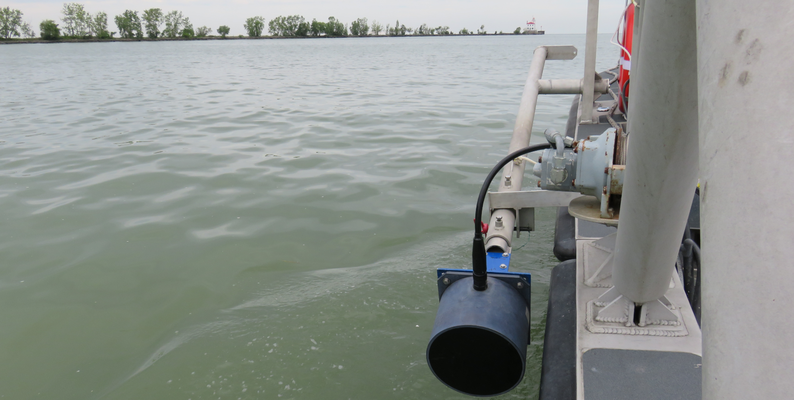
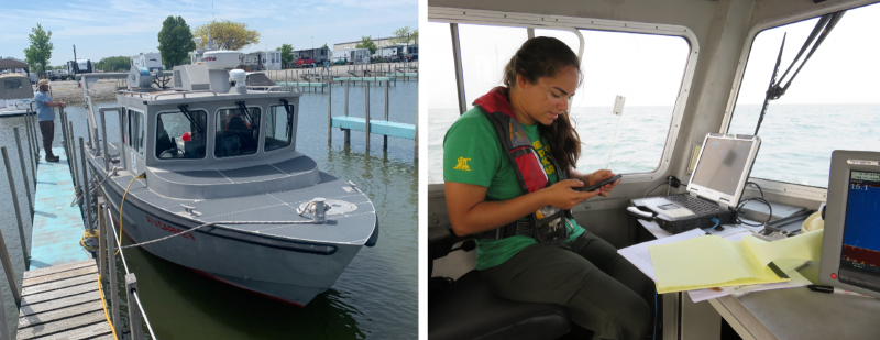
Hydroacoustic surveys will allow us to quantify yellow perch densities and distributions throughout the water column in targeted sampling areas and will provide abundance estimates between normoxic and hypoxic conditions. We will pair hydroacoustic surveys with ODNR’s bottom trawling surveys to verify species identities, measure fish size, and harvest fish for diet studies. We will also take depth profiles of temperature and dissolved oxygen at the sample sites. If we are able to use the Rowe model to predict spatial pattens in temperature and hypoxia 5 days in advance, we will target locations for field sampling using that tool. We are specifically interested in the mid-summer to mid-fall months, as these are the months in which recreational fishing for yellow perch and hypoxia-driven habitat and diet shifts are most likely to conflict. Hydroacoustic and bottom trawl sampling will be accomplished using RV Carmen.
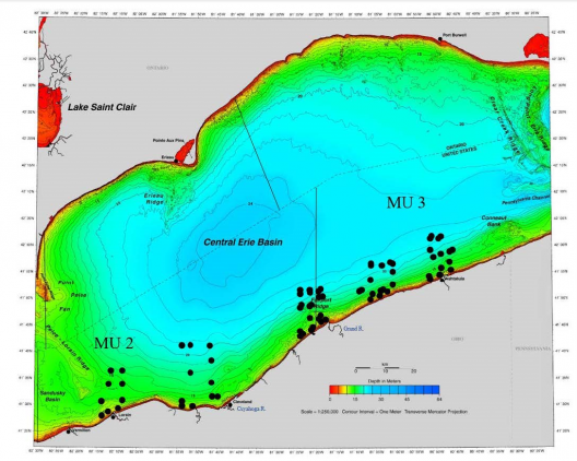
Trawl surveys will be conducted approximately every two weeks from July through October. Bottom trawls will consist of 10-min tows in waters deeper than 10 m and 5-min tows in depths less than 10 m with a Yankee-style two-seam bottom trawl. We will conduct biweekly surveys at five different sites, to collect at least two days of data per month of interest. When possible, we will pair our hydroacoustic surveys with ODNR-DOW trawling surveys (Figure 2) to reduce effort and number of fish removed from the lake. The frequency, timing, and location of surveys will also be driven by hypoxic conditions, which will be monitored using NOAA’s Great Lakes Coastal Forecasting System (GLCFS). If hypoxic conditions are changing rapidly and often, we may sample more frequently than two times per month; if ODNR-ODW trawl survey sites do not capture the range of environmental conditions in a given month, we will sample at different locations.
This project seeks to improve understanding on how novel patterns in environmental conditions are affecting yellow perch populations in the central basin of Lake Erie. Not only am I interested in learning how yellow perch distributions and movements are affected by different levels of hypoxic events, but also how their foraging behavior and diets change due to these changes in conditions. We will use the completed model to predict the distribution of adult yellow perch in response to hypothetical environmental conditions in 2021 and 2022. By doing this, we will be able to validate (or not) the model that has been developed and make necessary adjustments to certain model assumptions. Results from this model will provide improved understanding of yellow perch distributions and their overlap with fishing effort, including understanding the mismatch between population indicators from commercial catch and recreational catch. It will allow for assessment of temporal changes in the effectiveness of current sampling protocols and may provide suggestions for accounting for environmentally mediated impacts on survey effectiveness (i.e., habitat-based standardization).